
Friday, September 7, 2001 (click to see all posts from this day)
|
No late start today! At 5:30 I was rolling up my bag and heading down the road.
But I have still been aware of how the logistics hold me back, so I've made a few changes in my style. You can read more in today's Journal.
Kawasaki, Station #2 on the Old Tokaido
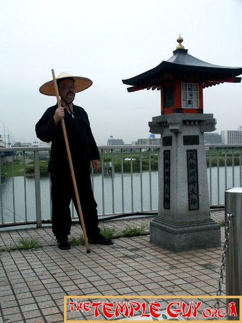
First order of business: my "official" photo of the Kawasaki station. I am standing in front of a monument to the Rokugo no watashi or the "Rokugo Ferry." This crosses the Tama River, the dividing line between Tokyo and Kanagawa Prefecture.
Of course, there's a bridge there now. But the paranoid Tokugawa avoided the building of bridges across large rivers, figuring it was harder to move an army across a ford.
Hiroshige's Tokaido: Kawasaki, Station #2 on the Old Tokaido
 Edo, and now Tokyo, have long been distinguished from the rest of the country. "Tokyo isn't Japan," new arrivals are often told. Traveling toward Tokyo is always "up" in Japanese, and away is "down," no matter the true direction. You can be in the far north of Hokkaido or down in Okinawa, and say "I'm going up to Tokyo." Even trains are announced as nobori and kudari--going up or down, to or from Tokyo. And so, this crossing is of great importance, as here one leaves Edo proper--and enters "the rest" of Japan. I felt it as I stood on the bridge in the twilight last night. |
As I walked along thinking about logistics, an important point slipped my mind: I didn't get a signature at the Kawasaki station. As the Japanese say, Saru mo ki ni ochiru--"Even monkeys fall from trees," or everyone makes mistakes. I'll try harder in the future (and try to simplify the logistics). [In fact, I made this mistake so consistently that I finally gave up. Read more here.]

Walking toward Tsurumi, I came across this beautiful old jinja or Shinto shrine, named Kumano Jinja. (There are many of these in Japan; the main one is in Wakayama Prefecture, south of Ise.) It wasn't on my map. Then I realized--it was between the two pages of the map! I have to be careful about this..
An Ichi-ri-zuka
Imagine this: Route 66 is no more, but an occasional milestone remains. So someone builds a church to commemorate the site of the milestone.
That's what you're seeing here. The Tokaido was measured in ri--about four kilometers, the distance a man (apparently except me) can walk in an hour.

Each ri along the highway was marked on either side by mounds of earth planted with trees. These were called ichi-ri-zuka--"one-ri-mounds." This small shrine has been situated on one such mound!
Upon reaching Tsurumi station, I sat in Donut-san (my name for Mr. Donut) for a couple of hours and worked on yesterday's homepage, then dumped my bag in a locker at the station.
Soujiji
Next stop: Soujiji, near Tsurumi station, where I said today's prayers. I've made a Words-and-Pictures page about it. This is one of the largest temples in Japan--a real contrast to yesterday's little jewel, Honsenji. This temple is on a grand scale, and has been right in my back yard all this time, but I had never visited it before.
I went into a gymnasium-sized office to have my book signed, and the young student at the desk--after reading my story--had an omamori or amulet made to protect my travel.
The Namamugi Incident
After lunch, I continued toward Yokohama. Along the way I saw a monument to the (in)famous "Namamugi Incident."
Near the end of the Edo (Tokugawa) period, Japan was caught in a vice. On the one hand was increasing internal tension between the supporters of the Shogun and those who wanted to restore Imperial power. On the other was the increasing external pressure to open the country to international exchange.
Conservatives campaigned under the slogan "Revere the emperor, expel the barbarians"--meaning Westerners.
In this climate, bad things were bound to happen. And so one fine day a party of three British men and a woman set out to visit the great temple Kawasaki Daishi. As they rode north near the village of Namamugi, a daimyo's procession was coming south. It was customary to dismount and pay reverence to the passing lord, but the Englishmen didn't know this. Nor did they understand the Japanese commands to do so.
What happened next has been debated. Did the daimyo give a command, or did the Samurai act on their own? In any case, the Englishmen were attacked, one fatally.

This is a monument on the site of that early blow to international relations.
An odd side-note: the village's name, Namamugi, means "raw (or fresh) buckwheat." And the area today is the site of a large Kirin beer brewery!
I couldn't possibly show you every old building, marker, monument, etc., that I see. But here are two nice things from today's walk:

This old building houses a rice shop.

This monument commemorates an old bridge.
Kanagawa, Station #3 on the Old Tokaido

The first ward of Yokohama City one enters is Kanagawa Ward. This name is now well-known as the name of the prefecture, but few realize it was originally the name of the 3rd station on the Tokaido when leaving Edo. The building behind me in my official shot of Kanagawa was the site of the main official inn (honjin) at Kanagawa.
Yokohama itself is an upstart, largely developed after the opening of Japan. But traces of sleepy little Kanagawa remain.

For example, I had my book signed by this railroad employee, Mr. Kiyoshi Hasegawa, in tiny Kanagawa Station on the Keikyu line. It's vastly overshadowed by the nearby Yokohama Station complex.
By the way, it always pleases me to see how people get involved in what I'm doing: Mr. Hasegawa suggested that he add the station's stamp (used in touring campaigns) for a touch of "authenticity"!
Hiroshige's Tokaido: Kanagawa, Station #3 on the Old Tokaido
 The bayside area of Yokohama has been re-engineered to such a degree that the site of this picture cannot be determined. The cliff-side shops, though, remind me of a story in Ikku Jippensha's Hizakurige, or "Shank's Mare." It's a comic novel written serially beginning in 1831, about two men roaming the Tokaido. When approaching Kanagawa, they are beckoned into one of the cliff-side inns. "There's plenty of room at the back," says the girl. "Of course there is," replies one of the travelers. "It runs all the way to Awa and Kazusa"--meaning modern Chiba Prefecture on the other side of the bay! I'll write more about Yaji and Kita, the travelers, when I meet them down in Shizuoka Prefecture. |
Hodogaya, Station #4 on the Old Tokaido

Nearing Hodogaya, I took a wrong turn and wandered up into the hills. When I get lost, I just figure "Adventure calls." And sure enough, I caught this great view of Yokohama's bayside area--something I would have missed if I hadn't gotten lost!

At Tennocho Station--which lies within the boundaries of the old 4th station at Hodogaya--is a little park with a fake "bridge" across it. This commemorates Hiroshige's print, so I did my best to reproduce it for my official shot at Hodogaya. (Of the several shots I took, I chose this one because of the lady on the right staring at me--not knowing she would be caught doing so on camera!)
All through my "photo shoot," a homeless guy sat and watched what I was doing. After I took the shot, I tried to get him to sign my station book. (Park, homeless guy--it seemed natural.) No luck. He wordlessly tried to send me to the police station or the train station--anything, I think, to get me to leave him alone.
I'll have to get my book signed tomorrow.
Hiroshige's Tokaido: Hodogaya, Station #4 on the Old Tokaido
 Remember, You'll have to look closely to see the difference between my shot and Hiroshige's. |
From Hodogaya station I returned to Tsurumi, fetched my bag, and headed to Kita-kamakura to stay with Tom and Yuka. A good bath, a relaxing evening--this is the way to do it!
| ← Previous Day | Back to Old Tokaido Guide | Next Day → |
Posted September 24, 2019
No comments:
Post a Comment